


The Good Water Trail around Lake Georgetown is one of our favorite hikes in Central Texas. The lake is a U.S. Army Corps of Engineers reservoir, so there is no private property on the lake. There are a few developed parks and campgrounds, as well as primitive campgrounds, all connected by the Good Water Trail, which is 16.5 miles in total length. April 16-17, Jen and I hiked in from Cedar Breaks Park to Cedar Hollow Camp, where we spent the night before returning the way we came.
These photos are copyright © 2005 Kenneth E. Harker. All rights reserved.
|
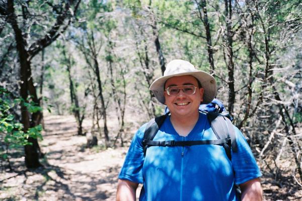
This is Ken, not far from the trailhead. Most of the trees in this part of the trail were mountain cedars. It was a brilliant sunny day as we set out just after lunch. |
|
Somewhere around the 3/4 mile point, the trail heads up to the top of a cliff over the southern shore of Lake Georgetown and follows the top of the cliff for a while. This is the view straight down to the lake. The lake has a really gorgeous aquamarine color on a sunny day. |
|
Two kayakers were enjoying the lake about fifty feet below us. On Saturday, the lake had all kinds of boaters out, from kayakers to sailboats to fishing boats to water-skiing boats. |
|
Jen, walking down the trail. This was our first trip with her new ultra-light backpack. We each carried our own sleeping pads, sleeping bags, change of clothes, and about four Nalgene bottles of water. Jen carried more of the food and the camp stove, whereas I carried the tent. |
|
On the southern side of the lake, the trail winds in and out of several inlets where small streams drain into the lake. |
|
Around 2.5 miles in is a beautiful place to stop for a break. A small stream fed by Crockett Spring flows through a pretty meadow before tumbling down a waterfall into the lake below. |
|
The stream water gently flows over these moss-covered rocks on its way to the falls a few feet below. |
|
In the meadow above the lake, there are lots of irises. |
|
This is a typical central Texas landscape. The trees are a mix of mountain cedars (also known as scrub junipers) and live oak. There are tall grasses and wildflowers, giant clumps of prickly pear cactus, and the occasional exposed granite boulder. |
|
Between Cedar Breaks Park and the Cedar Hollow Campsite, there are two footbridges that cross streams flowing into the lake. This is the first one that we came across, not long after passing milepost 3. The boards that were still there seemed to be in decent shape. The other bridge was of the same design, but had all of its boards. |
|
A view of Lake Georgetown from a high point on the trail somewhere between milepost 3 and milepost 4. It was a really gorgeous spring afternoon. |
|
We stopped for a short break between milepost 4 and milepost 4. Why the old rock cairn milepost 4 marker and the newer steel post milepost 4 marker are several hundred feet apart from one another is a mystery to me. |
|
Not far from our campsite, I think this is one of the best vistas of the lake and surrounding countryside. |
|
The Cedar Hollow Primitive Campsite is about 4.5 miles from the trailhead, and includes two large meadows right on the lake. There are three designated campsites, each of which has a picnic table, fire pit, and food pole. This is the view of the lake from our picnic table. |
|
We had the entire camp to ourselves overnight. This is the view from the edge of the lake looking at our tent and picnic table. We arrived a little after 4PM and spent the rest of the afternoon relaxing in camp. There's a double outhouse out of frame to the right and up the hill a ways. |
|
As dusk settles over the camp, everything began to quiet down. The lake was to our east, so the setting sun was behind us. |
|
The next morning was cooler and even slightly foggy. We slept in until well after sunrise. |
|
Looking through a gap in the trees to the south, vaguely in the direction we'd need to start our return journey. |
|
Unlike Saturday, Sunday morning was overcast and foggy. The lake doesn't sparkle in quite the same way as when the sun is out. |
|
We stopped for a midmorning snack at Crockett Falls, one of the most engagingly scenic spots on the trail. |
|
Some ruins of an old farm building close to Crockett Spring and the Crockett Falls. The fields are still actively used for cattle grazing today. |
|
Much of the trail goes through rock much like this. It is almost like Swiss cheese, except all the edges of the holes are sharp and precarious. There were several times I was glad to be wearing thick soled hiking boots. |
|
You get a long view of the lake to the west-northwest from a high point on the trail between milepost 1 and milepost 2. The gloomy skies must have kept many boaters away in the morning. |
| Last Updated 1 August 2018 |