


Jen and I spent a weekend in October in Mendocino County, California. We've already explored a lot of northern California, with multiple trips to both Napa County and Sonoma County. This was our first trip as far north as Mendocino County, north of Sonoma County. We stayed in the coastal town of Fort Bragg, and in addition to wine tasting in the Anderson Valley and the Ukiah Valley, we spent some time exploring the redwood forests and visiting with sea lions at the Pacific Ocean.
These photos are copyright © 2009 Kenneth E. Harker. All rights reserved.
We spent two nights at the Holiday Inn Express in Fort Bragg, California. Fort Bragg is a small town on the northern California coast, about 175 miles north-northwest of San Francisco. Founded in 1857 as a military fort, it was named after Braxton Bragg, an officer in the U.S. Army who would later become a general in the army of the Confederacy. The fort was abandoned by 1867, but the town grew with new settlers. The town has a long history with the lumber industry, and was a major source of the lumber that rebuilt San Francisco following the earthquake and fire of 1906. Today, Fort Bragg is becoming a tourist resort. Summer is the peak tourist season, so the town was not as busy while we were there.
|
Our hotel in Fort Bragg was perched above a scenic greenbelt along Hare Creek, just about 500 meters (1/3 mile) from the Pacific Ocean on the south side of the town. In the morning, the coastal fog rolled into the creek basin and softened the view of the trees in the distance. |
|
There were almost no buildings visible through the trees in the creek basin. Hare Creek is somewhere down in the bushes and trees. The main waterway in Fort Bragg is the Noyo River, which was not far to the north of our hotel. |
|
From the balcony of our room, you could see the Pacific Ocean just beyond the Pacific Coast Highway, also known as California State Route 1. Our hotel was about 80 feet (24 meters) above sea level. |
|
In the evening, the setting sun highlighted the few bits of orange and red in the trees. California doesn't get the same intensity of fall colors in the trees as other parts of the country. It was also really too early in the season for fall color; the best fall foliage was yet to come. |
|
The sun starting to set over the Pacific Ocean and our little creek. |
The Navarro River Redwoods State Park is in an eleven mile long, narrow valley of second-growth redwood forest along the lower Navarro River valley. All of the original growth redwood forest in the county was cut down long before we were born. In October, all the campgrounds and other services in the park are closed, but there are many places to pull off the road (California State Route 128) and go for a walk in the trees. We drove through the state park twice, on our way to the Anderson Valley in the morning, and then again on our way back to Fort Bragg in the afternoon. The redwood trees in this state park are not as big as the old growth redwoods in the Muir Woods National Monument, which we visited in 2004.
 |
In the morning, the light through the trees was very pretty. |
 |
The huge root stock from a fallen redwood. Root stock much smaller than this would merit marking on an orienteering map. |
 |
Looking up the trunk of a big redwood tree. |
 |
Some more redwoods. |
 |
Jen in the forest. |
 |
Some fallen branches covered in moss and ferns. |
 |
Not all of the trees in the forest were redwoods, and not all of the redwoods were mature, full-size trees. |
 |
Ken, next to the big trees. |
 |
A view through the trees. |
 |
These trees are not redwoods. |
 |
In the late afternoon, we drove back through the "redwood tunnel to the sea". The forest was darker and felt deeper. |
 |
Three big redwoods, surrounded by smaller trees. |
 |
Afternoon sunlight filtering through the redwoods. |
 |
Much of the forest floor was covered in ferns. |
 |
More sunlight streaming through the canopy. |
 |
Jen, in front of a redwood stump that was about six feet in diameter. |
 |
It seems surprising to me that these huge trees can grow so close to one another. |
 |
This was one of the prettier stands of redwoods in the state park. |
 |
Big trees everywhere. |
The Navarro Point Preserve is a 56-acre (23 ha) public park owned and managed by the Mendocino Land Trust. Navarro Point extends out into the Pacific Ocean just north of the mouth of the Navarro River. The park is a mix of coastal prairie grass, coastal scrub, some wetlands, and steep cliffs down to the ocean. There are over a mile of trails through the fields, but we only hiked the main loop from the parking area by the highway to the headland and back. A strong onshore wind was blowing, making for a cold walk.
 |
The sign in the parking lot laying down the rules. There were a couple of other cars full of people visiting the afternoon we were there. |
 |
The view from the parking area toward the north. The house in the distance was just outside the park boundaries. |
 |
Jen looks cold. The hills behind her were on the other side of California State Route 1 and outside the park boundaries. I'm sure the house on top of the hill is an expensive property with spectacular ocean views. |
 |
The trail through the prairie grass toward the cliffs over the ocean. |
 |
Looking north. The vegetation near the trail here is more scrub than grasses. |
 |
Looking south from the top of the cliffs over the beach. These cliffs are about 160 feet (50 meters) high, and there was no obvious safe route down them to the beach. |
 |
The cliffs to the north of Navarro Point. |
 |
The beach is all rocks and gravel and just looked really cold. |
 |
There was a stiff onshore wind blowing over the point. It was cold. |
 |
Some rocks at the bottom of the cliffs. |
 |
A raft of sea lions hauled out on the rocks far below us on the south side of the point. There was no practical way to get any closer to them, which was probably a good thing from the sea lions' perspective. |
 |
Looking south into the distance. |
 |
This is looking north. There was lots of seaweed in the water on this side of the point. |
 |
Looking south at the cliffs over the beach glowing in the setting sun. |
 |
Ken, at the far end of Navarro Point. It was really windy. |
 |
Jen was dressed a little more appropriately for the cold wind. |
 |
Looking northeast from the point back at the coast. The cliffs are about 160 feet (50 meters) tall. The homes on the hills are about 400 feet (120 meters) above sea level. |
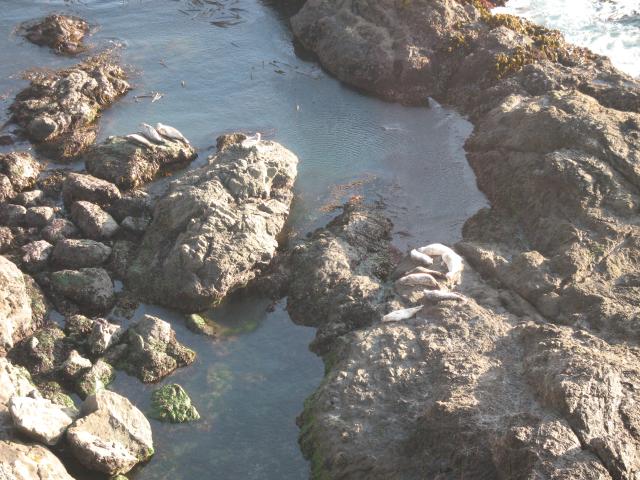 |
Walking back to the car, we again walked by the raft of about a dozen sea lions sunning themselves on the rocks at the base of the cliff. Most of the sea lions had spotted gray coats, but the bright sunlight made some of them look almost white. |
 |
Jen, on the trail back to the car. |
Just before sunset, we made a quick visit to Glass Beach on the north side of Fort Bragg. This beach was used as the public dump for the town for most of the twentieth century. Residents would simply carry their garbage to the top of the cliffs and toss it over the side. In 1967, dumping was stopped and cleanup efforts began to cleanse the beach. A legacy of the dump remains - millions of tiny fragments of sea glass, from broken glass worn smooth by the waves and beach gravel. Glass Beach is now a public park and something of an ironic eco-tourist attraction.
 |
We arrived at the beach just before sunset. |
 |
Like most of the northern California coast, the beach is mostly rocks and gravel. |
 |
These were the cliffs from which the town residents would hurl their garbage into the sea. |
 |
The brown sea glass stands out most prominently, but there was a lot of off-white sea glass as well. Probably a third of the gravel in this photo is really glass rather than rock. |
 |
A big square rock offshore. |
 |
Ken, just at sunset. |
 |
The sunset over the Pacific Ocean. |
 |
A line of clouds was on the horizon in the distance over the ocean. |
| Last Updated 18 December 2025 |